Interesting the way estimates work. Rarely to the extreme even when the extreme would be justified.
Case in point, let's look at 2010's Hurricane Igor, which is near peak intensity (or so it would seem) even as I write this. As of 11 AM EDT the National Hurricane center estimates Igor to have winds of 150 mph and a central pressure of 933 mb, making it officially a strong Category 4 storm. It is notable that these are estimates, as Igor is too far out in the Atlantic for hurricane hunter aircraft to reach it with their data-collecting instruments. Also notable is the fact that these estimates are based on satellite imagery.
Now, having watched hurricanes since I was 9 years old, I know that it is very rare to see a storm reach Category 5 intensity (even though an astounding 5 of them did it in that unreal 2005 season), which requires sustained winds of 160+ mph (technically 156 but it always rounds to the nearest 5) and usually results in a central barometric pressure lower than 930 mb. I also know that in those rare CAT 5 storms, two things are always seen via satellite imagery: one is a perfectly circular eye, and the other is concentric banding around the eye. In other words, the deepest thunderstorm activity and thus the highest cloud tops will form a circle around the eye indicating that the storm is in perfect vertical alignment. Under such perfect conditions, intense winds well into the CAT 5 range are likely.
A good example is 2007's Hurricane Dean, which reached peak intensity just a few hours before making landfall on Mexico's Yucatan Peninsula about 100 miles south of Cancun. At that point hurricane hunters found winds of 175 mph and a central pressure of 907 mb, and satellite imagery showed the concentric effect that I had previously mentioned.
Now let's consider 2010's Hurricane Igor, Igor's satellite imagery shows a structure every bit as well-defined as Dean's, yet the National Hurricane center does no estimate a CAT 5 storm. Not to say that it didn't atttain these winds, as Earl showed a nearly concentric structure briefly on September 1 of this year but was found to be a CAT 4. However, I will show the photos side by side, and you be the judge.
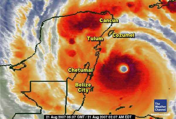
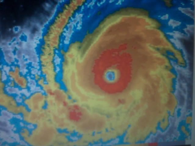
LEFT: Dean, 8/21/07, Winds 175 mph, Pressure 907 mb from hurricane hunter. RIGHT: Igor, 9-13-10, Winds 150 mph (est), Pressure 933 mb (est)
Do you think Igor is getting jipped here? In my experience that ringed eye structure has almost always resulted in winds of 160 mph+ and pressure lower than 930 mb when the storm is close enough for measurement.
And another case in point: Remember that Hurricanes Hugo (1989) and Andrew (1992) were rated CAT 4 storms at the time of their existence, only to have been upgraded to CAT 5 upon later satellite analysis (Andrew at landfall in south Florida, Hugo out in the open Atlantic). Just something to think about.
_________________
~Nick
Misunderstood since 1979